Natural Caves
Although the geology Kent and Sussex is not particularly good for the formation of natural caves, a number of recent discoveries have shown, contrary to the opinion of many cavers and geologists, quite extensive cave systems can be found in the chalk. Small caves also occur in other rock including sandstone and 'Kentish Rag' (a sandy limestone), and including several important sites of archaeological or palaeontological interest. There are also numerous examples of sea-worn caves scattered around the chalk cliffs of the Kent and Sussex coastline. None of the latter are very extensive, only rarely going beyond the limit of daylight penetration, but they can be quite roomy and make nonsense of the widely-held belief that chalk is too unstable for cave development. One example in the Seven Sisters cliff near Cuckmere measures 65ft in length and up to 50ft wide.
The processes involved in the formation of inland caves in chalk or limestone are extremely complex and are still not fully understood. Basically they are the result of water dissolving and eroding the rock along crevices known as joints, bedding planes and faults. Caves formed by free flowing streams with an air space above are known as 'Vadose' systems, while for those which are completely waterlogged the term 'phreatic' is used. Caves of both types which are now drained of the streams that formed them are described as 'fossil' systems. Most of the chalk caves so far discovered in Kent and Sussex fall into the 'fossil phreatic' category.
Caves can also form when large masses of rock resting on unstable clay simply move apart, leaving what is in effect a large crack. These are known as 'tectonic' or fissure caves and are often associated with landslips. A good example in chalk is Beachy Head Fissure near the lighthouse situated on the cliff top above a landslip. It consists of a 50ft shaft leading to a tall natural passage, descending to a depth of about 70ft. Similar caves in sandstone occur at Cowden and behind the fishing huts at Hastings. The well-known Ightham Fissures in Kentish Ragstone were also probably formed in this way.
A number of streams in S.E. England sink underground in what are generally referred to as sinkholes, swallets or swallow holes and these features have often been used as evidence of cave development in chalk. The best-known example is at North Mimms in Hertfordshire where the Mymmshall Brook sinks into the chalk and has been traced by dye tests to springs up to 11 miles away. Good examples also occur in Kent at Lower Ensden near Chartham where several streams draining off the clay sink into large swallets, up to 60ft wide and 40ft deep at the clay/chalk boundary. One of these holes has a cave mouth at the bottom but it is blocked after a few yards. An interesting recent development was the discovery of a natural chalk cave system in a previously unrecorded swallet at Warren Row in Berkshire. The lower Ensden swallets are almost identical to the Warren Row example and in some cases are considerably larger and take a lot more water.
It is also encouraging to know that the French have been searching for caves in the chalk region of the Paris Basin, which is actually the continuation of the North and South Downs on the other side of the Channel. In spite of 'expert' predictions that any such caves would be small and uninteresting, they have explored numerous examples of up to 2 kilometres in length. Nearly all these French caves were found in wells and this has led to speculation that the underground streamways were located by water divining. On one occasion, the Water Services of Paris are said to have asked a dowser to indicate the exact point at which to dig a well. Their engineer was not convinced, however, and decided to sink a 90ft shaft to one side of the point indicated. At a depth of 60ft there was no sign of water so they dug a tunnel in the direction shown by the dowser - here they met the course of an underground river.
Early Geological Survey publications and natural history journals contain several interesting references to similar caves in Kent. In 1879 workmen digging a tunnel from a well at Strood Waterworks broke into a large natural cavern containing running water, which was eventually explored for about 200ft. Another reference in 1907 described a cave in a well at Knockholt which measured 30ft long, 18ft high and 12ft wide with a stream flowing through it. A similar cave and watercourse is said to have been entered at a well near Chatham and three separate caves were discovered at Blackheath during the construction of a sewer tunnel. Unfortunately, none of these early finds are accessible today.
More recently, the search for chalk caves has concentrated on the sea cliffs. In addition to the sea caves, there are many cavities at various heights in the cliffs which cannot have resulted from marine erosion. Some of these are infilled with rubble or sediment but others are open cavities large enough to enter. Most of these cavities are inaccessible but some examples near the base of the cliffs have been explored. These include Canterbury Cave and Beachy Head Cave, the latter extending for well over 1,000ft.
Another rock which might conceivably contain caves is the sandy limestone known as 'Kentish Rag', The River loose near Maidstone flows underground in this rock for a distance of a quarter of a mile at Boughton Quarries and, although the valley has been altered by artificial landscaping and quarrying at its sides, the disappearance of the stream appears to result from natural causes. There are also three very powerful springs emerging from the ragstone near West Mailing and the volume of the water is such that it suggests streams flowing in open cavities rather than seepage through porous rock.
Natural caves can also form in gypsum. This rock does not outcrop at the surface but it is extensively mined at Brightling and Mountfield (see GYPSUM MINES). Conversation with some of the miners seems to confirm that natural caves have been encountered and the miners refer to these caves as 'washouts'.
Canterbury Cave
The entrance to this cave lies on the south side
of St Margaret's Bay, just above the high water mark. The name 'Canterbury Cave'
first appears on a map of the South Foreland in 1960 and it is apparently a
local name for the cave. At that time it was presumed to be a sea cave and it
was not until 1975, when it was examined and surveyed by members of Chelsea
Speleological Society, that its true significance was realised. It soon became
obvious that the cave could not have resulted from marine erosion as it was
above the normal range of the tides and quite extensive. What had happened is
that the cliff had exposed a fossil cave system originally formed by an
underground stream.
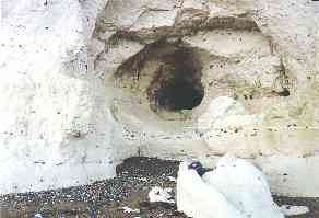
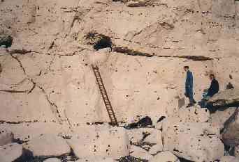
The entrance is a large recess behind a pile of boulders which have fallen from
the cliff face. At the rear of this opening, a passage averaging 7ft wide x 4ft
high extends into the cliff in a N.W. direction. About 80ft from the entrance,
the passage bends to the right and opens into a small chamber 30ft long x 12ft
wide x 5ft high, before resuming its original direction after a sharp left turn.
The roof and walls of the chamber have a pitted, sponge-like appearance which is
characteristic of a cave originally formed under 'phreatic' conditions when the
passage was completely filled with water.
About 50ft beyond this chamber, the passage veers to the left and becomes a flat
out crawl for about 20ft. The crawl ends at a T-junction with a roomier passage
trending north and the obvious way on is to the right. After crawling over and
around boulders for a further 70ft, the cave appears to end in an impenetrable
fissure, but closer inspection reveals a low opening on the left hand side. This
leads to another stretch of roomier passage, the end of which is choked with
rubble and boulders just over 300ft from the entrance.
To the left of the T-junction, the passage continues southwards but rapidly diminishes in size and is almost choked with sediment, apparently derived from the Thanet Sand which overlies the chalk in some areas. The passage was eventually explored in this direction for about 45ft by digging out the floor and, during the excavation, a number of rat and rabbit bones were unearthed. At the furthest point a small fissure branches off to the left but the way ahead is completely blocked.
The total length of explored passages is 360ft. The passages are clearly joint-orientated but there is another less obvious feature that may have had a considerable influence on the development of the cave, i.e. the thin sheet of tabular flint seen beneath the floor near the entrance. In the cliff face nearby, the chalk above the upper surface of the flint is honeycombed with tiny cavities only a few inches wide. It is interesting to note that the cross sections of the cave discovered at Strood Waterworks also show a flint seam at floor level. Further examples of caves floored with tabular flint can be seen in the cliffs at Beachy Head. These flint layers probably form an effective water barrier which results in a saturated (phreatic) zone above the normal level of the water table. Water held up in this way must eventually drain away, following any Incline in the strata or leaking into unsaturated rock below wherever the continuity of the flint is interrupted by faulting, etc. This would result in significant underground water movements, particularly along the joint structure on the upper surface of the flint.
Beachy Head Cave
This is one of the several caves situated in the spectacular chalk cliffs at Beachy Head near Eastbourne. The entrance lies in a particularly inaccessible location near the base of a 300ft vertical cliff and involves a difficult climb to a ledge 14ft above the beach. This ledge is an exposed bend in a cave passage with two low, semi-circular openings leading off into the cliff. The cave was eventually explored and surveyed by members of Chelsea Speleological Society during 6 visits in 1980. Careful planning was required to avoid being cut off by the tide!
To the right of the ledge, the passage extends for 585ft and ends at a 'sump' where it continues full of water. The cave passages are very small and progress is slow - mainly flat out crawling with only occasional sitting or standing space. The floor is either covered with dried out mud or littered with flint nodules, and the whole place is literally crawling with fauna - spiders, gnats, moths, etc. The passage follow~ the joint network of the chalk with many sharp bends but maintains an overall trend in a N.E. direction away from the cliff face. There are several small tributary passages, including a tube-like opening in the roof which can be climbed to a height of 25ft.
The only significant change in the character of the main passage is a curious 14ft drop down a perfectly circular tube inclined at 45 degrees. Beyond this, the previously dry and dusty cave suddenly becomes very damp with slimy black deposits on the walls and puddles spreading across the floor towards the end. It is in this damp section that the only cave formations are seen - some small but attractive crystals and a 'botryoidal' stalactite resembling a cauliflower.
The left hand passage is initially very similar to the right hand series. It extends for 465ft and nearly touches the cliff again in three places where daylight enters from tiny tube-like openings. The passage beyond the second point of daylight penetration is noticeably different from the rest of the cave, formed along a fault with a boulder strewn floor and plenty of standing space. This is followed by two very tight crawls, beyond which the passage steadily increases in size until it is 6ft wide x 5ft high before heading downhill through a series of S-bends. At the bottom of this slope, another very tight crawl leads to a mud-floored passage with the channel of a tiny dried up stream down one side. The passage finally ends where the sediment comes to within a few inches of the roof but it could probably be extended by digging.
As in the caves at Strood and St Margaret's Bay, the cave is formed above a thin tabular flint layer and sudden changes in the level of the passages seem to coincide with displacement of the flint by faulting.
The total length of explored passages is 1,160ft, which makes it the longest so far discovered in the English chalk, and the depth below surface is 300-400ft. It is now one of the 50 caves in Britain scheduled as Sites of Special Scientific Interest. Since the cave was surveyed, some spectacular cliff fails have created two new entrances in the left hand series. The original entrance ledge has also collapsed, effectively splitting the cave into two.
Kingsgate Sea Caves
The chalk cliffs of the Isle of Thanet originally contained over 100 caves but most of these have now been destroyed by the construction of sea defences. Some of the best remaining examples are situated in the relatively unspoilt cliffs of the Kingsgate area where various paths and steps provide easy access to the beach at low tide. The largest cave in this area is 'Smugglers Cave’ situated in Kingsgate Bay behind the Captain Digby pub. This is over 200ft long x 30ft high but has obviously been artificially enlarged with a high level side passage and blocked shaft at the end, which originally led to the surface. Nearby is the entrance to 'Tower Cave' which is entirely natural and extends for about 100ft.
& man made tunnels
At the western end of the bay, the headland known as Whiteness Point is pierced by a natural sea cave and a system of manmade tunnels. One of the tunnel entrances is accessible at high tide and a hole in the floor provides a spectacular view of the sea cave below, especially during rough seas. A sketch of this area made by Mr R. Staniforth in 1960 shows these tunnels but not the sea cave, so presumably it did not exist at that time. The rate of erosion is certainly extremely rapid as it has taken less than 30 years for the sea cave to penetrate the 70ft wide headland. Eventually it will collapse and form an isolated stack, similar to those in the adjoining Botany Bay area. None of the other caves in the area shows any significant changes since Staniforth made his sketches but a natural arch in Botany Bay has collapsed to form a new offshore stack.
Archaeology & Palaeontology
There are three locations in Kent which have provided interesting finds relating to the late Pleistocene period some 50,000-100,000 years ago. The well-known 'rock shelters' at Ightham are small natural caves and overhangs which occur in the sandstone crags along the eastern edge of Oldbury Hill. Many interesting features, including at least one fairly substantial cave, have unfortunately been destroyed by quarrying of the outcrops during the early 19th century. The main group of rock shelters surviving today consists of 8 low openings beneath overhanging rocks, some of which interconnect in the form of a small but quite complex cave system with over 150ft of passages. The caves occur in a soft, silty layer sandwiched between hard chert, which forms the roof, and harder sandstone below. They appear to have resulted from differential weathering of the rock outcrops and erosion by springs. It is interesting to note that a small stream rises from a spring at a similar level on the northern side of the hill.
In 1890 a local archaeologist, Benjamin Harrison, directed an excavation which resulted in the discovery of a large collection of Palaeolithic (early Stone Age) flint implements. These were recognised as 'cave dwelling types' almost identical to those found at Le Moustier in France. Unfortunately, there is considerable confusion as to the location of these finds.
A more recent excavation by Desmond and Anne Collins (1965) failed to find any evidence of occupation in the immediate vicinity of the surviving rock shelters but, further down the hillside, more examples of the distinctive 'Mousterian' implements were found. They concluded that, whilst there was no definite evidence of occupation of the shelters in their present-day form, it was possible that the implements were associated with a former rock shelter now destroyed by natural erosion or quarrying. Further excavations could throw more light on the subject but there would seem to be little doubt that it was the shelter provided by the natural caves and overrhangs that attracted the Palaeolithic tool makers to this area some 50,000 years ago.
Another interesting site near Ightham was the 'Ightham Fissures', discovered and subsequently destroyed by quarrying in the years preceding 1894. A photograph of the site in Bennet's book titled 'Ightham' shows three narrow openings in a ragstone quarry, the largest about 3ft wide. What made these features particularly interesting was the wealth of Pleistocene fossils found inside. The remains comprised 27 land snails, 47 mammals, 3 reptiles, 2 amphibians and 20 birds. The mammals included mammoth, woolly rhinoceros, brown bear, reindeer, red deer, roe deer, horse, wolf, hyena, wild boar, badger, common and arctic fox, otter, weasel, polecat, pika, pouched marmot, mole, shrew, field mouse, 5 species of bat and several species of vole and lemming. It will be seen that some of these animals are now extinct or no longer present in the British Isles, whilst others are still common species today.
There are also references to a 'Boughton Cave' near Maidstone where the remains
of mammoth, woolly rhinoceros, reindeer and red deer were found.